
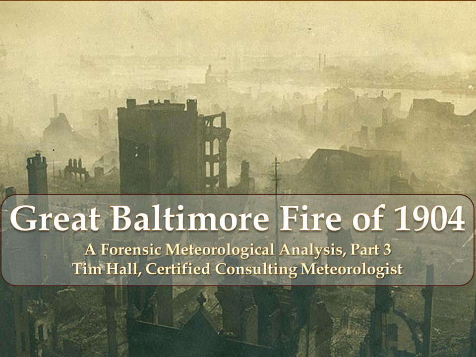
Evolution of the Weather and the Fire, Feb. 7-8, 1904
For the purposes of synchronizing the progression of the fire over time to changes in weather for this forensic analysis, I parse the event into three phases aligned with the shifting weather conditions shown below the x-axis. Phase I spans 10:45 a.m. to 7:30 p.m. on Feb. 7 during the southwesterly flow ahead of the cold front. Phase II is the westerly wind regime and spans from estimated cold front passage at 7:30 p.m., Feb. 7 until winds shifted to the northwest, as strong cold air advection kicked in at around 11:40 p.m. Phase III represents the northwesterly wind regime from 11:40 p.m., Sunday, Feb. 7 until the fire was declared under control at 5:00 p.m. on Monday, Feb. 8.
Phase I, Southwesterly Wind Regime
At around 10:00 a.m. the morning of Sunday, Feb. 7, winds freshened out of the southwest as pressure fell ahead of the approaching cold front. Winds peaked at around noon in Phase I with winds above rooftop level of 18 knots gusting to an estimated 24 knots, and generally in the range of 12 knots gusting to 18 knots throughout the period. In the warm sector ahead of the cold front with partly to mostly cloudy skies, abnormally warm temperatures for early February spiked at a balmy 64℉ at noon.
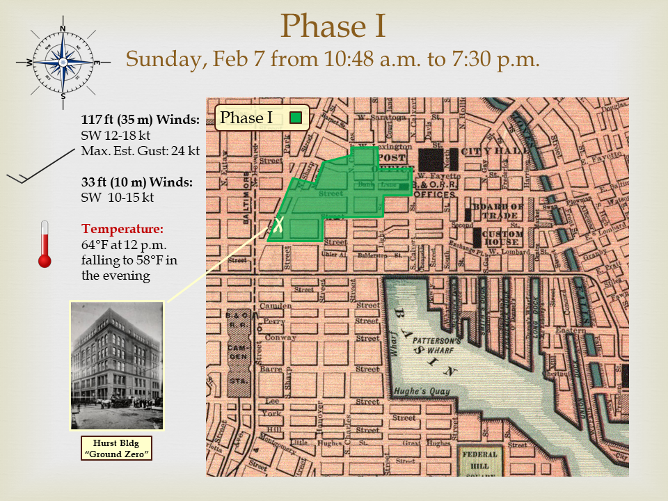
While both the city air and the basement of the Hurst Building were heating up around 11:00 a.m., the firefighters at Engine Co. 15 were preparing for morning inspection. At 10:48 a.m. they received an automatic alarm from the John E. Hurst & Company Building (white X), located between Hopkins Place and Liberty Street on the south side of German Street. The official investigation later concluded that the fire most likely started when a lit match or remnant of a cigar or cigarette fell through a broken section of a glass deadlight in the sidewalk above into the basement of the Hurst Building, where blankets and cotton goods were stored [5]. The fire was believed to have smoldered for hours before the alarm was triggered.
As recounted in the Baltimore News on Monday, Feb. 8, about 5 minutes after the initial alarm, "a sharp splitting roar went up with reverberating thunder followed by a peculiar whistling noise like that made by a shrill wind."[6] This gaseous explosion known as a back draft, occurred when oxygen suddenly, violently re-entered the smoke-filled portion of the burning Hurst Building. About a dozen people in the vicinity were thrown to the ground by the shock wave.
The explosion shattered windows and shot firebrands into nearby buildings. Driven by the strong southwesterly winds that had kicked in about 45 minutes earlier, it was reported by Chief Horton (pictured center) that "brands of fire at once began to be blown several blocks away, setting fire to rubbish in yards and awnings, the flames of which immediately entered broken windows" [5]. Officials on the scene immediately began to fear the fate of the entire city.
Realizing the imminent risk of rapid spread, Chief Horton summoned nearly all of the Baltimore City Fire Department including 24 engines and 8 hook & ladders to the scene. A witness reported that, "the gale held steadily from the southwest, filling the streets with flying embers, stinging the face and igniting wearing apparel, the wearers protecting themselves from fire brands as they would from a winter's storm." [7]
At 11:55 a.m., Chief Horton requested help from Washington, D.C. Urgently, two engines were placed on a special train and hurried to Baltimore over the Baltimore & Ohio Railroad in record-breaking time of 37 minutes, arriving at about 1:30 p.m. Their effectiveness would, unfortunately, be limited as the D.C. company's hose couplings wouldn't fit Baltimore's fire hydrants (due to a different thread pattern) and as a work around, the poorly fitted couplings were wrapped in canvas to try to create a seal. In the end, ten fire companies converged on Baltimore from New York City, seven from Philadelphia, five from Washington D.C., four from Wilmington and one or more companies from Baltimore Co. (Maryland), Sparrows Point (Maryland), Annapolis (Maryland), York (Pennsylvania), Harrisburg (Pennsylvania), Chester (Pennsylvania), and Altoona (Pennsylvania).
While directing the firefighting, Chief Horton was burned by a live electrical trolley wire and District Engineer August Emrich assumed command. Chief Horton was carried on a patrol wagon to No. 23 Engine House where he remained in a semiconscious condition until Monday morning. He recovered and later led the formal investigation in the aftermath of the event and authored the official report. [5]
In the early afternoon, George M. Upshur, President of The Board of Police Commissioners, requested help from police departments in Washington, D.C., Philadelphia, New York City, and York (Pennsylvania). Police were essential to assuring public safety during the event and in its aftermath. As the fire expanded from a single building to a larger area, spectators who converged on the danger zone were kept safe by a thin blue line and ropes. Police shifted the rope to move crowds back one block at a time as the fire spread discontinuously from roof-to-roof.
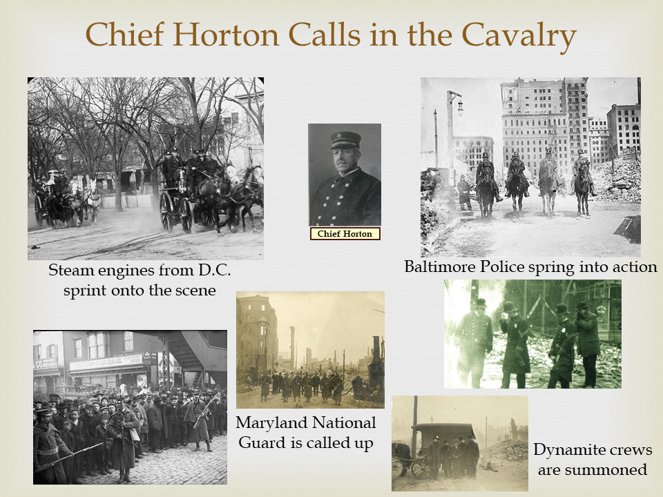
At about 5:00 p.m., dynamite crews arrived on scene (lower right) and got to work attempting to level approximately 15 buildings to create a firebreak. Unfortunately, the explosions did not level the structures, but instead blew out the windows and accelerated the fire's spread by allowing more oxygen to fuel the flames in these structures. At around 6:00 p.m., Brigadier General Lawrason Riggs called up the Maryland National Guard. 2,000 soldiers and sailors were on duty by midnight to prevent looting and generally help maintain order in the midst of chaos. With the western half of the heart of Baltimore now fully involved (see green shaded area) and the situation growing increasingly dire by the minute, the weather conditions created huge challenges.
In mass urban fires, local conditions on the ground reflect microscale phenomena associated with interaction of the large-scale prevailing winds and the urban landscape. Wind flow through an urban area is subject to increased friction (relative to the surrounding region), channeling (through "street canyons") and funneling through narrow corridors and alleys. This creates turbulent eddies along the edges and in the lee of structures, causes the wind to swirl, curl, or spin up into transient vortices, and can accelerate or decelerate the ambient flow.
At ground level, the combination of these phenomena can lead to conditions experienced by observers as highly changeable or seemingly random. Accounts from first responders and witnesses from the Baltimore Fire bear this out. While chaotic lowlevel winds frustrated efforts to extinguish the flames, the prevailing wind flow drove the fire's rapid spread through direct flame contact and downwind streaming of dangerous firebrands.

Wind speeds at and just above rooftop height, and flowing down street canyons oriented parallel to the wind direction reflected the prevailing flow with gusts into the mid-30s (knots). In locations with narrow streets and alleys oriented counter to the flow, flames tilted (similarly to the photo) and breached the gaps between buildings.
Weather Effects on Spot Ignition [9, 10]
Wind is the most critical factor in spot ignition through its enhancement of firebrand generation, transport and recipient fuel ignition. Strong winds increase the size of the fire and enhance the buoyant force in the fame and plume which enables it to loft larger brands. In turn, strong winds can transport firebrands further downwind. Note that drag force on a firebrand is proportional to the square of the wind speed. Wind also supplies oxygen which helps ignite recipient fuels and accelerates the transition from smoldering to flaming combustion. Lower relative humidity also helps ignition because dry air is a less efficient heat sink while firebrands are in transport.
For a given wind, spotting distance depends on the lifetime of burning firebrands [10]. Spotting distance increases as the fire grows larger and becomes more intense (i.e., hotter) creating stronger inflow and vertical updrafts that loft larger firebrands into the air for transport [9, 10].
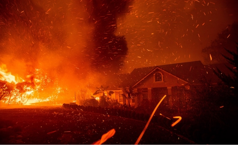
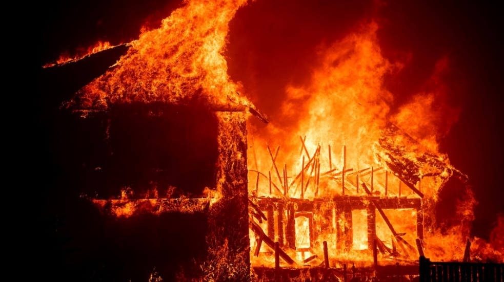
Spot ignitions by windborne firebrands lofted by strong convective updrafts and swept downstream is the primary mechanism for spread of urban conflagrations [8, 9] and frequently thwarts fire suppression. Based on Albini [10], the maximum spotting distances associated with firebrands originating from the tallest structures in the heart of Baltimore in this fire would likely have been in the 0.3 to 0.5 mile range. Longer distance spotting is often associated with fire whirls which boost the potential height attained by firebrands as they rise above their source. The largest brands (greater than 1 inch) pose the greatest risk. Fireman William Young dramatically described the windblown fire brands that created a horrific scene during the Baltimore fire. "It was the greatest night I ever saw in my life…A hurricane of wind carried clouds of ashes and lurid sparks that resembled a blizzard from hell" [7]. Perhaps the scene looked like the moment captured below during California's tragic wind-driven Camp Fire in November 2018.
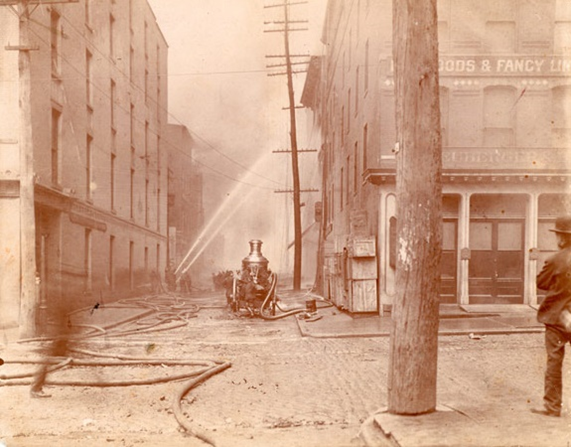
The photograph in the figure above was taken looking west from German and Hanover Streets as firefighters sprayed water on buildings on German Street. Using a steam pumper and hoses, they were attempting to extinguish firebrands landing on the roofs of dry goods dealer S. Neuberger and Brother located at number 14 Hanover Street and collar and cuff manufacturer, Cluett, Peabody and Company at 104 West German Street. This image clearly illustrates the setting across Baltimore's business district as described by Petersen [7]:
"Narrow streets, just thirty to forty feet wide from curb to curb, created a funnel for spreading flames which was exacerbated by haphazard construction…People recalled looking down a block and seeing flames leap from rooftop to rooftop similar to a forest fire where flames leap from tree top to tree top."
Fire behavior described as "leaping" from rooftop to rooftop has been observed in other conflagrations such as Chicago (1871) [11] and London (1666) [12].
Phase II, Westerly Wind Regime
At around 7:30 p.m., Feb. 7 a strong cold front swept through the city and with it the wind shifted to westerly. This halted the northern progress of the fire but, in turn, pushed it eastward into the heart of downtown. Winds above rooftop height (117 feet above ground level) at the Baltimore WBO were west at 10-20 knots gusting 15-25 knots with an estimated peak gust of 30 knots (35 miles per hour) at 11:00 p.m. Temperatures continued to hover in the low 50s (℉).
From late afternoon into the evening, the fire migrated from Liberty Street and German Street to Lombard Street, spreading primarily by spotting from rooftop to rooftop. Witnesses described the fire as skipping two or three rooftops downstream at a time. By 8:00 p.m. the fire moved down Lombard, German, Baltimore and Fayette Streets barreling straight into the heart of the financial district (see yellow shaded region) 15). As reported later in the Fireman's Record in 1911 [13] the sky overhead during this phase of the fire, "was filled with flying fire - borne from west toward the east."
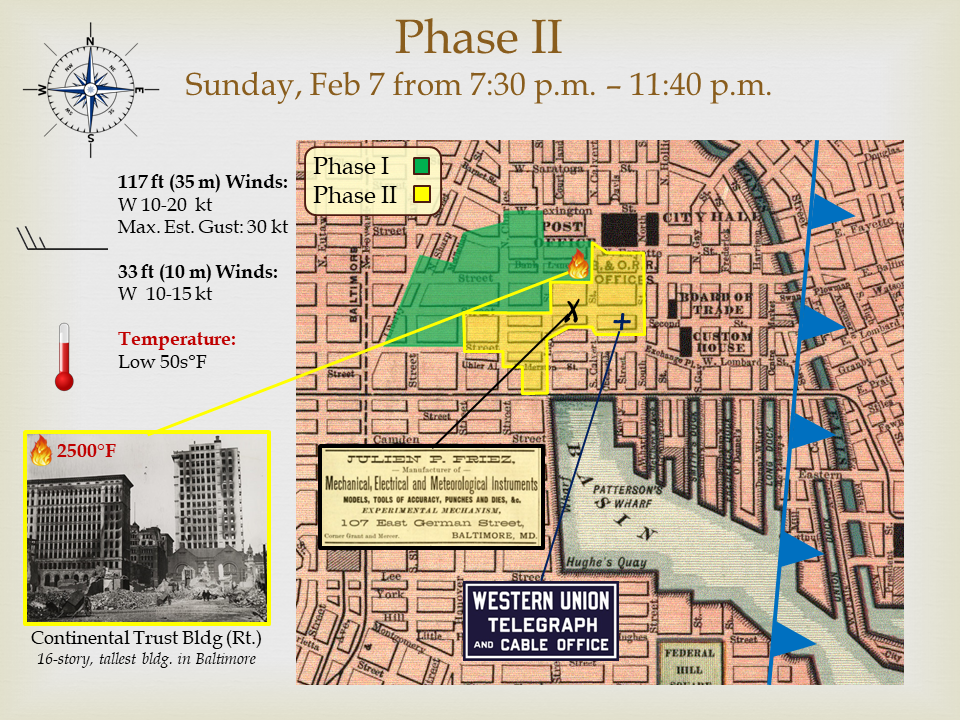
At about 10:00 p.m. as the blaze moved east, the Baltimore & Ohio Railroad Building (near the northern tip of the shaded yellow area) at the northwest corner of Baltimore and Calvert Streets ignited. Fifteen minutes later, flames shot up the tallest building in Baltimore, the 16-story Continental Trust Building (pictured on the lower left of adjacent figure as it appeared after the fire), which had previously been proclaimed fireproof. This "skyscraper" and several others nearby could not be reached by the streams from any fire hose. Eventually, the heat generated in this area overwhelmed the firefighters, who retreated. In the post-event investigation, clues from melted metal structures inside this building and surrounding buildings indicated that the heat had reached at least 2500℉. The glow of Baltimore'\s burning skyscrapers at this point was visible from as far away as Washington, D.C. There is evidence of potential fire whirl activity during Phase II near the Continental Trust Building. The Fireman's Record [11] documents the following observation made in this area during the time it was fully involved: "Overhead, high in the air, the swirl of flying embers could be seen slowly circling toward the southward in obedience to the direction of the wind."
An interesting anecdote from Phase II of the fire was recorded in the journal of the Baltimore WBO [14]. Located at the + in the adjacent figure in the yellow fire zone was the Baltimore office of the Western Union Telegraph Co. The Weather Bureau relied on this office to send and receive certain weather information. As the fire approached, the Baltimore WBO noted that, "Mr. Wren at the Western Union Telegraph Co. was able to assemble a map and succeeded in getting from Washington a special forecast of wind before being driven out of the building by the rapidly advancing fire."
In a cruel twist of irony near the end of Phase II, the Friez Co. was incinerated. The history of the Friez Co. was recounted in a 1929 thesis by George Phipps [15]. In 1876 the Ottmer Mergenthaler Co, manufacturers of precision instruments of all kinds moved their offices to New York City to focus on linotype machines. In response, Julian P. Friez, superintendent of Ottmer's scientific and precision instrument branch, decided to strike out as an entrepreneur and establish his own factory on the corner of German and Grant Streets in Baltimore at the X in the adjacent figure. The name of his company was Julian P. Friez & Sons, Manufacturers of Weather Instruments. One of the first and most widely known Friez instruments was the Robinson cup anemometer which was first used by the U.S. Weather Bureau in Washington, D.C. in 1885. By the mid-1890s, the Friez anemometer and other instruments were installed in nearly all Weather Bureau offices across the country which would certainly have included the Baltimore Customs House station in 1904, according to Weather Bureau records. The business would recover after the fire and is considered the heritage of the Belfort Instrument Company which continues to manufacture and sell meteorological instruments in Baltimore today.
Phase III, Northwesterly Wind Regime
Just before midnight, the wind direction shifted from west to northwest as cold air poured (i.e., advected) into the city, initiating Phase III of the fire. The northwesterly wind shift mercifully halted the eastward progress of the fire, preserving key government structures. As reported in the Baltimore Sun Almanac in a 1905 retrospective, "Extreme exertion helped to save the magnificent row of public buildings on St. Paul Street to Holliday Street - the Court House, the Post Office and the City Hall. But it was more by a fortunate change of the wind…that saved these structures, than any human effort." The wind shift, however, sealed the doom of the area between the heart of the business district and the Harbor to the south, and Jones Falls to the east.
During Phase III from 11:40 p.m. Sunday to 5:00 p.m. Monday, firefighters faced their most challenging conditions. In his 1904 report [5], Chief Horton stated that, "So great was the wind and the vacuum caused by the heat, that deluge streams were torn to fragments and could not reach the second stories." This reflects the highly variable low level wind conditions described earlier that result from the synoptic ambient winds, turbulent flow around urban structures, and fire-generated inflow combining to create locally chaotic conditions. In a modern pamphlet published by the Fire Museum of Baltimore, these highly localized conditions from the perspective of the individual firefighter's on the scene were described as "erratic."
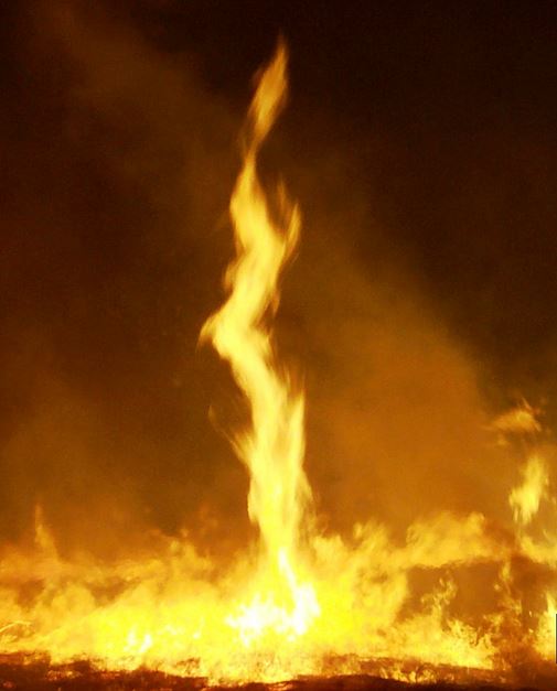
Urban conflagrations, like forest fires, create their own weather through an inflow of mass into the hottest areas of the fire [16]. Inflow speeds have been measured between 5-10 knots in research settings [17] and upwards of 30 knots in infrared video analysis [18]. When inflow interacts with ambient winds, tall convective columns ventilated by strong winds can extend well above rooftop levels (as illustrated in figure above) 16) and small scale, short-lived whirlwinds or fire whirls can form. Fire whirls have been reported in urban conflagrations with notable examples including Tokyo after the 1923 earthquake and Great Fire of London in 1666.
A fire whirl is a whirlwind induced by a fire. Whirls usually draw in flame and ash and can loft dangerous fire brands up in the atmosphere to heights greater than would otherwise occur in a firegenerated convective updraft. Fire whirls (with or without taking in flames) tend to occur when intense rising heat and turbulent wind conditions combine to form a whirling eddy. Preexisting vorticity (i.e., spin in the atmosphere) is not a necessary condition. Whirls can form in seconds, are usually 33-165 feet tall, 5-10 feet in diameter, reach heights of tens up to thousands of feet, and are typically transient — lasting only a few minutes at most. They are commonly observed during large fires but are also observed during small-scale fire testing [8]. They are most likely to occur where the convective column is tilted out of the vertical by strong ambient winds [16] such as those that prevailed in Baltimore on the night of Feb. 7-8, 1904.
Assuming the southward heading of swirling embers in the witness account above is representative and relatively accurate; this observation was probably made around 11:40 p.m.. The extreme heat in the area of the Continental Trust Building combined with potential fire whirl activity suggests that the maximum altitude of larger firebrands would have been achieved in this area. I assess a high likelihood that this area was the source of the firebrand that sparked a secondary fire a third of a mile to the southwest at Centre Market at around midnight (B).
After midnight, the structure of the overall fire grew increasingly complex. First, the primary fire at (A) in the above figure propagated to the southeast, tearing through the heart of the financial district toward Jones Falls. As discussed above, a second conflagration started when a dangerous firebrand landed on the roof of the Maryland Institute Association of Mechanical Arts (Maryland Institute) at Centre Market. The Maryland Institute is pictured as it appeared before the fire on the lower left of the Phase III figure below.
A tertiary area of fire representing the southwestern front (C) of the primary fire was moving slowly to the east and southeast toward the piers. Meanwhile, the continuation of the main area of fire reached (D) shortly after 3:00 a.m. At this time, an apparent "Uturn" of the propagation of the fire against the wind occurred at the southern end (E) of the second conflagration that had started at (B) [7]. This was most likely associated with a firebrand traveling downstream in the continuing strong northeast winds from the eastern edge of the main fire (D), which was about 0.1 miles west of (E).
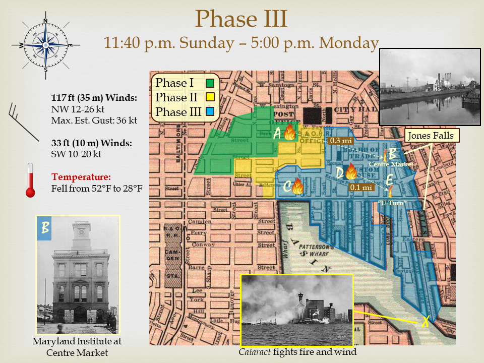
Between 3:00-7:00 a.m. Monday morning, the separate elements of the fire merged and swept through the piers to the Harbor on the south and Jones Falls on the east. At Jones Falls, a combined force of local and mutual aid fire companies mustered 37 steam fire engines and made a stand to block the fire moving east into the dense tenements. The fireboat Cataract (pictured, bottom), revenue cutter William Windom and a flotilla of tug boats concentrated on saving the Savannah Pier (X). It was reported that the Cataract drew water from the basin and propelled it with considerable force, but the strong wind in the fireman's faces diffused the streams, rendering many of them ineffective [7].
During the morning hours, firefighters extinguished numerous spot fires east of Jones Falls. In the final analysis the valiant stand at Jones Falls and Savannah Pier was helpful, but in reality the natural fire breaks created by Jones Falls and, of course, the Harbor finally ended the nightmare of this mass fire.
Conclusion
In the final analysis, the wind conditions on Feb. 7, 1904 morphed the initial emergency at the Hurst Building on Liberty Street into a quickly growing inferno that threatened heavily populated tracts of the city to the north and east of the Burnt District. Local wind conditions on the ground cannot be reconstructed in detail without applying a powerful computational fluid dynamics model. But, I am certain that the fire spread by strong winds that created a storm of blowing firebrands and tilted flames across Baltimore's narrow alleys and streets. To a reasonable degree of meteorological certainty, a complex flow regime created by turbulent eddies caused by flow over and around structures and the funneling and channeling of the flow in the cities street canyons combined forces with the inflow created by the fire itself to frustrate firefighting efforts throughout the hellish event.
Furthermore, I assess that conditions were conducive to fire-generated whirlwinds in the vicinity of the strong convective uplift in the area of the Continental Trust Building, likely lofting dangerous firebrands hundreds of feet into the smoke-filled night sky. Firebrands from this area landed on the roof of the Maryland Institute at Centre Market and other nearby structures igniting the secondary fire. In Phase III, a final northwesterly shift of the wind direction associated with cold air advection, lagging a few hours behind the front and building high pressure, drove the fire into natural breaks at Jones Falls and Baltimore's Inner Harbor. This spared the tenements to the north and east and prevented an epic disaster which would certainly have rivaled the devastating scope and cost of the wind-driven Great Chicago Fire of 1871.
Over the course of 32 hours, 140 acres in the heart of Baltimore were incinerated. While in some respects 140 acres may seem like a relatively small parcel of land, one can put it in into context by comparing the cost of devastation to recent wildfires in the U.S. In 2017, western wildfires in the U.S. consumed 9.8 million acres with a cost of $18.4 million which translates to $1800 per acre [19]. In 2016, western wildfires burned 5 million acres at the cost of $2.5 billion or $500 per acre [19]. In the Baltimore fire, the torching of 140 acres cost the equivalent of over $4 Billion in 2018 U.S. dollars or about $29 million per acre. The Great Baltimore Fire of 1904 stands as the third worst conflagration of an American city in history. It took about two years for Baltimore to completely rebuild.
![As the fire quickly developed, some business owners (photo on left in above figure)
desperately moved valuable merchandise from stores ahead of the approaching fire line. This
picture was taken along Charles St at 1:00 p.m., Sunday Feb. 7 about a quarter of a mile from
the Hurst Building (see approaching smoke in the background of the photo) [9].](images/Fig 19 Slide 6 - Part 3.png)
Postscript —a curiosity in the aftermath:
The photo below is Anderson and Ireland Hardware Store at Light and Pratt St. from [20] in the southeast corner of the fire zone. Firefighters doused the structure as temperatures fell below freezing Monday afternoon and evening to ensure that gunpowder, kerosene and other flammables in the basement didn't explode. Pictorial evidence reveals that a number of other structures were also ice encrusted following the fire due to continued fire suppression efforts from mid-afternoon and into the evening of Monday, Feb 8.
[1] Sun Magazine (Title of article not available), Henry F., Published February 1, 1948.
[2] U.S. Daily Weather Maps available at: https://library.noaa.gov/Collections/Digital-Collections/US-Daily-Weather-Maps
[3] Anemometry (Circular D, Instrument Room), C. F. Marvin, Published 1893, U.S. Department of Agriculture, Weather Bureau, 40 pp. https://github.com/WeatherSleuth/1904-Baltimore-Fire/blob/master/Anemometry_Marvin_1893.pdf
[4] Wind Speeds Over Short Periods of Time, C.S. Durst, Meteorol. Mag., 89: 181-186, Published 1960.
[5] Report of the Chief Engineer, George W. Horton, Published 1904.
[6] The Baltimore Sun Almanac, Story of the Baltimore Fire, Published 1905.
[7] The Great Baltimore Fire, Peter B. Petersen, Published 2004 by the Maryland Historical Society, Baltimore (Md.), p. 192. ISBN 978-0938420903
[8] Wind Effects on Fires, W. M. Pitts, Prog. Energy Combust. Sci., Vol 17: 83-134, Published 1991.
[9] Firebrands and spotting in large-scale fires, Eunmo Koo and co-authors, International Journal of Wildland Fire, 19, 818-843, Published by CSIRO Publishing.
[10] Spot fire distance from burning trees-a predictive model, F. A. Albini, General Technical Rep. INT-56, Published 1979 by U.S. Forest Service
[11] The Great Conflagration: Chicago - its Past, Present and Future, J.W. Sheahan and G.P. Upton. Published 1872 by Union Publishing, Philadelphia, PA.
[12] The Great London Fire 1666, W.G. Bell. Published 1920 by John Lane Company, London.
[13] The Fireman's Record, J. Albert Cassedy, Vol II, Published 1911 by The Association, 336 pp. Available from UMBC Digital Collection: http://contentdm.ad.umbc.edu/cdm/compoundobject/collection/firemensrec/id/340
[14] Baltimore Weather Bureau Office Daily Journal from 7-8 February, 1904. Available from National Centers for Environmental Information (NCEI).
[15] History of the J.P. Freiz & Sons Co, A Thesis Prepared for the Phi Mu Honorary Engineering Fraternity, George R. Phipps, 1929, 15 pp. Available at https://github.com/WeatherSleuth/1904-Baltimore-Fire/blob/master/history_of_jp_friez_co_1929.pdf
[16] Mass Fires and Fire Behavior, C. M. Countryman, Rep. PSW-19, Published 1964 by the U.S. Forest Service
[17] Fire weather conditions and fire-atmosphere interactions observed during low intensity prescribed fires - RxCADRE 2012, C.B. Clements and co-authors, International Journal of Wildfire, 25, 90-101, Published 2016 by CSIRO Publishing.
[19] Billion-Dollar Weather and Climate Disasters, National Centers for Environmental Information as of 21 Dec 2018. Available at: https://www.ncdc.noaa.gov/billions/events/US/1980-2018
[20] Souvenir of The Baltimore Fire , February 7th, 8th, and 9th, 1904 As Seen Through a Camera, Hement, J. , Published 1904 by the A.B. Benesh Company available through Library of Congress, Digitized Internet Archive: https://archive.org/details/souvenirofbaltim00heme/page/n1
[21] Illustrated Catalogue of Meteorological Instruments and Apparatus (A Handbook of Meteorology in Respect to Standard Meteorological Instruments), Julien P. Friez, Published 1893 , 77 pp. (Smithsonian Library) https://github.com/WeatherSleuth/1904-Baltimore-Fire/blob/master/Friez_catalog_1893.pdf
Acknowledgements
Special thanks to Stephen Heaver, Director & Curator of the Fire Museum of Maryland, Lutherville, MD and to the rest of his staff for their interest in this project, and assistance in locating and accessing materials in the museum's historical archives. Also, thank you to Ken Hall for his assistance in mining the stacks at the museum.
Note: All images are in the public domain (pre-1923) unless otherwise noted.
Figure 6. Lower left: Baltimore Business District from Federal Hill, 1903. (http://www.shorpy.com/node/12633) - permission for use granted via personal communication, Dec 2018. Upper right (anemometer): Freiz Catalog [21] (https://github.com/WeatherSleuth/1904-Baltimore-Fire/blob/master/Friez_catalog_1893.pdf) Source of map: http://alabAMAMaps.ua.edu/historicalmaps/us_states/maryland/Baltimore.htm
Figure 10. Lower left: Baltimore St. looking east from Liberty St (Library of Congress) (https://www.loc.gov/item/89709552/) Photo of Hurst Bldg: (http://collections.digitalmaryland.org/cdm/singleitem/collection/mdbf/id/183/rec/172) Source of map: (http://alabAMAMaps.ua.edu/historicalmaps/us_states/maryland/Baltimore.htm)
Figure 11. Upper left: D.C. companies racing into action (Library of Congress) (https://www.loc.gov/item/2016844567/) Upper right: Baltimore Mounted Police (https://baltimorecitypolicehistory.com/) Chief Horton Photo: Fireman's Record 1911 Available from UMBC Digital Collection: (http://contentdm.ad.umbc.edu/cdm/compoundobject/collection/firemensrec/id/340) Lower left: National Guard (Library of Congress) (https://www.loc.gov/item/2016844573/) Lower Middle: National Guard (Library of Congress and Maryland Historical Society (http://mdhsphotographs.tumblr.com/post/75914714665/looking-southeast-from-continentaltrust-building) Lower Right: Maryland Historical Society (http://www.mdhs.org/digitalimage/baltimoregreat-fire-1904-demolition-crew-dynAMite-apparatus)
Figure 12. Photographer, Noah Berger (not in public domain, used by permission)
Figure 13. Picture lower left: (http://collections.digitalmaryland.org/cdm/singleitem/collection/mdbf/id/50/rec/45) Digital Image of Freiz sign is ad insert of Julien Friez in the R.L. Polk & Co's Baltimore City Directory of 1892. (http://belfortinstrument.com/julie-p-friez/) Image of J.P. Freiz: (http://belfortinstrument.com/julie-p-friez/)
Figure 14. (http://collections.digitalmaryland.org/cdm/singleitem/collection/mdbf/id/32/rec/30)
Figure 15. Image upper right: Jones Falls (Library of Congress) (https://www.loc.gov/item/2016844555/) Image lower right: Fireboat Cataract (Maryland Historical Society) (http://www.mdhs.org/digitalimage/baltimore-great-fire-1904-view-harbor-during) Image lower left: Maryland Institute (https://everipediastorage.s3.amazonaws.com/NewlinkFiles/4704950/25570518.jpg)
Figure 16. Photographer, Noah Berger (not in public domain, used by permission)
Figure 17. Fire whirl. U.S. Fish and Wildlife Service Photo, Public Domain (https://en.wikipedia.org/wiki/Fire_whirl#/media/File:Fire_whirl_(FWS)_crop.jpg)
Figure 18. Upper left: Baltimore St. West of Hanover St. early 1900s (http://collections.digitalmaryland.org/cdm/singleitem/collection/cator/id/78/rec/13) Upper right: Baltimore St looking east (http://collections.digitalmaryland.org/cdm/singleitem/collection/mdbf/id/7/rec/7) Lower right: Baltimore St (Library of Congress) (https://www.loc.gov/item/2016826957/) Lower left: Baltimore and Chase Street, c. 1900 (Maryland Historical Society)
Figure 19. Right: Charles St. north of Baltimore St., source unknown Left: Charles St., source unknown
Figure 20. Upper left: Baltimore St. west of Hanover St. early 1900s (http://collections.digitalmaryland.org) Upper right: Baltimore St looking east (http://collections.digitalmaryland.org/cdm/singleitem/collection/mdbf/id/7/rec/7) Lower right: Baltimore St (https://www.loc.gov/item/2016826957/) (Library of Congress) Lower left: Baltimore and Chase Street, c. 1900 (Maryland Historical Society)
Figure 21. Upper picture: Baltimore Business District from Federal Hill, 1903 (http://www.shorpy.com/node/12633) - permission for use granted via personal communication, Dec 2018 Lower picture: (https://www.loc.gov/item/2007662234/) (Library of Congress)
Figure 22. Source [20] (Library of Congress) (https://archive.org/details/souvenirofbaltim00heme/page/n1)
_crop.jpg)